
Historic Landscape Visualization
Topic: Period modeling for historic cultural landscapes
Date: May-November 2019
Location: Liberty Island and the Statue of Liberty, NY
Software: SketchUp, AutoCAD, Lumion, Adobe Photoshop
A combination of traditional archival research and digital graphic methods were used in the digital reconstruction and visualization of cultural historic landscapes for the Statue of Liberty and Liberty Island.

This project was hosted in partnership with the American Conservation Experience (ACE), the National Park Service’s (NPS) Olmsted Center for Landscape Preservation (OCLP), and the State University of New York College of Environmental Science and Forestry’s (SUNY ESF) Cultural Center for Landscape Preservation (CCLP).
PROJECT SCOPE
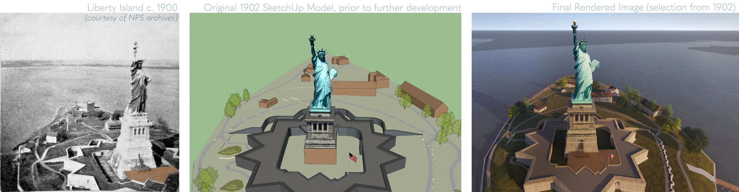
The goal was to create a series of digital graphic renderings in the style of ‘repeat photography’ for six (6) years of interest in the island’s history. These years included 1840, 1880, 1902, 1937, 1956, and 2019. These digital renderings complement the National Park Service’s current practice of using repeat photography to document changes in cultural landscapes over time. These images will be included in the Statue of Liberty and Liberty Island’s Cultural Landscape Report (CLR), a detailed document that explores a site’s history, cultural significance, and future treatment and stewardship of the cultural landscape.
PROGRAM WORKFLOW
Historical Imagery and Documentation | AutoCAD | SketchUp | Lumion | Adobe Photoshop

SKETCHUP TERRAIN GENERATION
A major task in the project involved the generation of new terrains for each of the six SketchUp models. These terrains are smoother, more accurate, and more geometrically complicated than the previously existing terrain models.
SketchUp Model Development
Existing documentation at the start of the project included AutoCAD files for each of the six years, as well as early SketchUp models. Further development of these SketchUp models included new terrain generation, fort detail scaling and detail, addition of missing planar geometry, building treatments, and material application.


CUSTOM MATERIAL CREATION
Custom materials were created in Adobe Photoshop using photographs from site visits. Treated components include the fort walls, coping stone, terreplein walls, terreplein pavements, and pedestal walls. These elements in the model display the exact textures as their physical counterparts.
FINAL DELIVERABLES
Shown here are three of the eight produced vantage sets that were created for each of the six models, for a final total of 48 images. Each set focuses on a different component of the island’s history, such as circulation, spatial organization, or views and vistas. Final rendering, material applications, and plant material placements were completed in Lumion. Additionally, Adobe Photoshop was utilized for custom texture creation from site visit photographs, contextual skyline development, and general post-processing of the rendered outputs.

See the process unfold on Anna’s Designing the Parks blog here.